API Manual
Terraqt Restful API
Version Information
- Version : 1.0
- Published: Jan 25th, 2022
- Last Updated: Feb 25th, 2022
Interface Introduction
Introduction
- TerraQuanta provides a convenient interface calling service, which can help users quickly embed TerraQuanta’s data products into existing map applications, achieving a strong fusion of spatio-temporal data products and user applications.
- Our interface meets users’ demand to develop front-end component, allowing further development and implementation.
Why API?
- Access methods TerraQuanta provides include SaaS, SDK, and API. User can choose the most appropriate method as needed. The differences are shown in the chart below. If you wish for a more flexible frond-end component development, API is recommended! | | Description | Characteristics | Development Difficulties | Map Display Flexibility | | ---- | ---------------------------------------------------------------------------------------------------------------------------------------------------------------------------------------------------------------------------------------------------------------------------------------------------------------------------------------------------------------------------------------------------------------------------------------------------------------------------------- | ----------------------------------------------------------------------------------------------------------------------------------------------- | ------------------------ | ----------------------- | | SaaS | No need for installation, debugging, or training, TerraQuanta’s standardized spatiotemporal data SaaS service helps spatiotemporal data users to view various data products and use various functions designed by us through a simple login. TerraQuanta SaaS User’s Manual | Simply log in and use through our website, no need for further development. | None | Low | | SDK | TerraQuanta provides users and developers who have limited experience in map application development with a complete front end spatio-temporal data product SDK component. This component is designed based on the low code concept, and it can embed the spatiotemporal data front end display module designed by TerraQuanta into other application interfaces without a trace, and can open or hide various functions freely.[JS-SDK Access Manual](/docs/基础概念/SDK嵌入服务) | Simply copy 7 lines of code to access. An experienced front-end engineer can realize this within 10 minutes. | Low | Medium | | API | TerraQuanta provides standardized map layer tiling services for users and developers with experience in map application development. Our service help users quickly access our layer data and achieve a strong fusion of patio-temporal data products and user applications | Flexible front-end map component development, easy access of WMTS layer, and strong rendering effects | Medium | High |
Basic Standards
- Transfer Method: HTTP
- Submit: POST or GET
- Data Format:
Jsonfor both submission and return data - Return data basic structure:
- Structure of interface return data includes 5 parameters
| Parameter Name | Data Type | Description |
| -------------- | ----------------------------------------- | ----------------------------------------------------------------- |
| code | `int` | Return status code | | success | `boolean` | Return result: true = success, false = failed | | msg | `string` | Error messages | | retry | `boolean` | Retry? True/false | | data |
object| Business data. Please refer to description of returned paragraphs |
- Structure of interface return data includes 5 parameters
| Parameter Name | Data Type | Description |
| -------------- | ----------------------------------------- | ----------------------------------------------------------------- |
| code | `int` | Return status code | | success | `boolean` | Return result: true = success, false = failed | | msg | `string` | Error messages | | retry | `boolean` | Retry? True/false | | data |
Major Concepts
- Service (serviceId):
- TerraQuanta packages different spatio-temporal data products that users require into one single service
- Each service contains key information such as product types, data time, and data spatial range
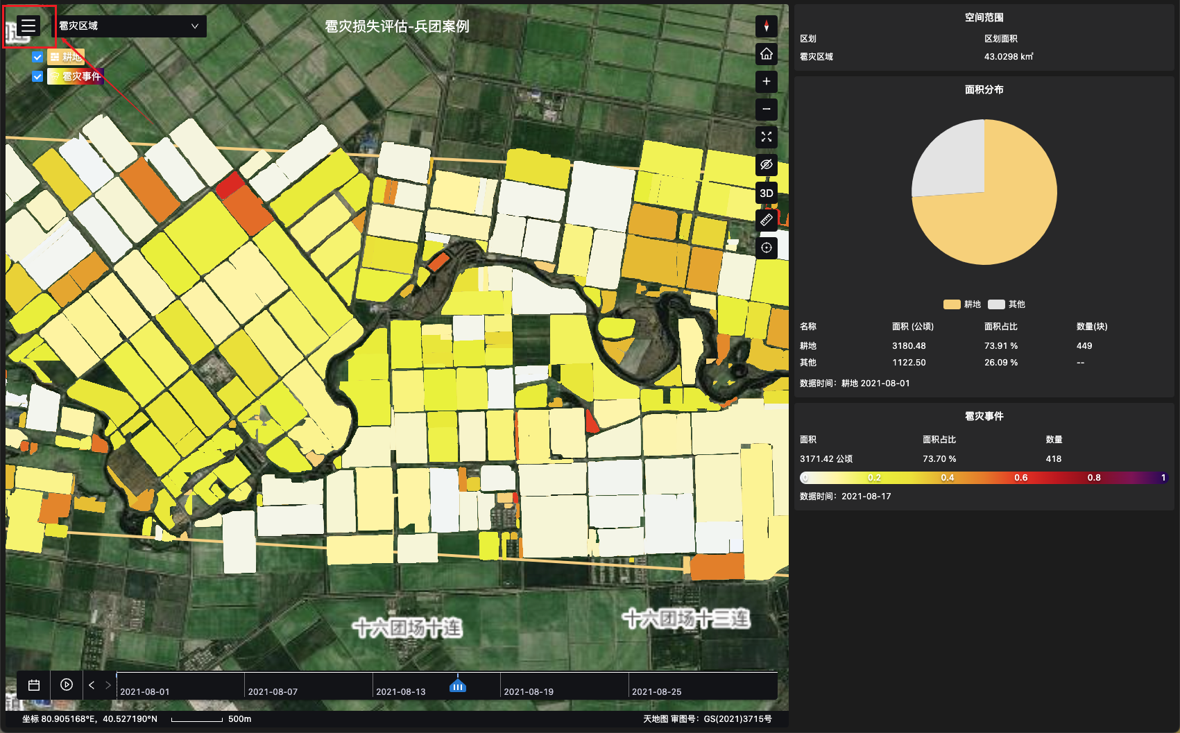
- *All service data tied to the TerraQuanta SaaS account can be accessed by users. , Log in to see the list of services.
- As shown above, the service “Land Usage Monitoring - Inner Mongolia Case” displays data products of land usage.
- Data Product (tqDsCode):Data product selector components
- TerraQuanta provides a variety of spatio-temporal data products, including crop identification, forest identification, crop growth monitoring, water quality indices, subsidence monitoring, flood monitoring, etc.
- Data products has three categories: Core (cor), Derivatives (der), and Events (eve)
- Each data product has a unique code (tqDsCode), which can be used to search and acquire data of that product
- Spacial Scale (spaceKey):Space selection module
- Different data products correspond to different spacial scales
- Users can search data products of certain scales with spaceKey.
- TerraQuanta provides two sets of spacial scales, administrative space and customized space。
- Administrative Space (adminSpace):
- Space divided according to Provinces/States, Cities, Counties based on national regulations
- Customized Space (customSpace):
- Space divided according to demand, such as the space of a farm or a reservoir.
- Data Timeline (timeLine):Timeline module
- The time attribute of the spatio-temporal data. For example, identifying a forest on the first day of every month results in twelve identification data in a year.
- Data Update Frequency:
- Different data products has different update frequency, which could be once a month or several times a month
- In order to obtain the newest data timely, please check the update frequency of the data product before development
- WMTS Layer (dataFile):WMTS Layer Rendering
- WMTS layer is the layer-URL based spatio-temporal data results provided by TerraQuanta. The layers can be displayed in map applications with the WMTS layer link.
- WMTS layer needs to be overlaid on a satellite imagery map or a vector map as demand. As shown above, the base map TerraQuanta chooses is from Tianditu.
- For a detailed introduction of WMTS layer services, please check WMTS Layer Service
- Layer has data types of vector and raster. Read What is Raster and Vector Data for specifications.
- Statistics (databox):Statistical data display module
- Statistics of related data products are returned along with the acquired layer, and users can develop data visualization with ways that they prefer.
Interface Manual
Follow the steps below to access our interface!
Preparation Work
Obtain account token and service ID
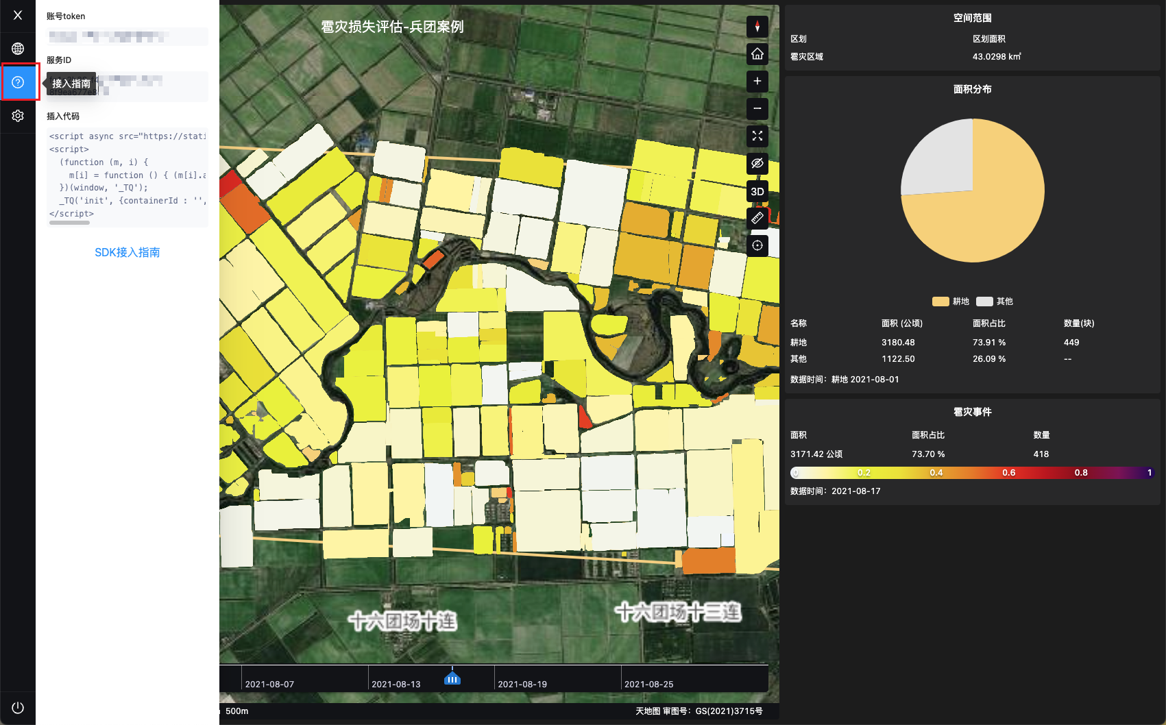
Obtain Identity Verification Information
Interface Description:
- Obtain user identification code ( secret ) with account token ( token)
- secret is used in identity verification when requesting other interfaces
Request URL:
Request Method:
- POST
Header:
- Host:<calculated when request is sent>
Parameter:
| Parameter Name | Required? | Type | Description |
|---|---|---|---|
| token | Yes | string | Account token |
Input Example:
{
  "token": "XXXXXXXXXXXXXXXXXXXXXXX"
}
Return Data Body
| Parameter | Description |
|---|---|
| userGuid | User ID, same as token |
| secret | Identify verification code. Used when requesting other interfaces |
| description | Description |
Return Example
{
  "success": true,
  "code": "200",
  "msg": "success",
  "retry": false,
  "data": {
    "userGuid": "XXXXXXXXXXXXXXXXXXXXXXX",
    "secret": "XXXXXXXXXXXXXXXXXXXXXXXXXXXXXXXXXXXXXXXXXXXXXXXXXXXXXXXXXXXXXXXXXXXXX",
    "description": null
  }
}
Data Interface
Obtain data product and its spacial scale included in the service
Interface Description
- Obtain the data product type, map legends, and spatial range information with serviceId
- Through the interface, users can acquire code and spatial scale of data products, and ready up for obtaining corresponding data layers in later steps
Request URL:
Request Method:
- GET
Header:
- Host:<calculated when request is sent>
- user-id: User ID, same as token
- secret:Identity verification code
Parameter:
| Parameter Name | Required? | Type | Description |
|---|---|---|---|
| serviceId | Yes | string | Service ID |
Input Example
{
  "serviceId": "fe1c2b38-f447-4290-a6d7-8f9ea677e8d3"
}
Return Data Body
| Parameter Name | Embedded Parameter | Description |
|---|---|---|
| serviceId | Service ID | |
| customSpace | Information of customized space | |
| cspace_key | Unique ID of customized space | |
| parent_cspace_key | ID of parent space of the current customized space | |
| name | Name of Customized Space | |
| adminSpace | Information of administrative space | |
| aspace_key | Unique ID of administrative space | |
| parent_aspace_key | ID of parent administrative space of current administrative space | |
| name | Name of administrative space | |
| serviceName | Service name | |
| prodList | List of data products | |
| cor_list | Core data product list | |
| der_list | Derivative data product list | |
| eve_list | Event data product list | |
| code | Code of data product | |
| name | Name of data product | |
| parent_code | Code of related data product (For example, related data product of long term monitoring could be wheat or rice. Different related TQDS correspond to different data layers)) | |
| type | Data product layer type (tms= raster layer,obj= vector layer) | |
| tqDsConfigs | Data product attribute information (legends of data product map layers) | |
| tqdsCode | Code of data product | |
| tqdsType | Type of data product (cor=Core, der=Derivative, eve=Event) | |
| tqdsCustomColor | Data product legend colors | |
| type | Legend type(palette=single value coloring, interp=interpolated coloring,discrete=discrete coloring. Read WMTS Layer Front End Rendering Example” for more descriptions | |
| value | List of legend colors | |
| color | Legend color | |
| label | Name of legend | |
| dn_value | Layer value. When legend type is interp, the return value will display dn_value_anchor, same as dn_value; When the legend type is discrete, return value will display dn_value_start and dn_value_end, representing the start and end value of corresponding legend. When legend type is either interp or discrete, different values in layers will display in different colors. | |
| unit | Legend unit, such as millimeter, meter, etc,. No value means no unit. |
Return example:
{
  "success": true,
  "code": "200",
  "msg": "success",
  "retry": false,
  "data": [
    {
      "serviceId": "fe1c2b38-f447-4290-a6d7-8f9ea677e8d3",
      "customSpace": [
        {
          "cspace_key": "227b3482-ea64-49b2-9d69-e343a51f43e7",
          "parent_cspace_key": null,
          "name": "Hail Affected Area"
        }
      ],
      "adminSpace": [],
      "serviceName": "Hail Damage Assessment - Corps Case",
      "prodList": {
        "cor_list": [
          {
            "code": "cor101",
            "name": "Farmland",
            "type": "obj"
          }
        ],
        "der_list": [],
        "eve_list": [
          {
            "code": "eve1.d",
            "name": "Hailstorm",
            "parent_code": ["cor101"],
            "type": "obj"
          }
        ]
      },
      "tqDsConfigs": [
        {
          "tqdsCode": "cor101",
          "tqdsType": "cor",
          "tqdsCustomColor": {
            "type": "palette",
            "value": [
              {
                "color": "#f8d072",
                "label": "Farmland",
                "dn_value": "1",
                "dn_value_anchor": null,
                "dn_value_start": null,
                "dn_value_end": null
              }
            ],
            "meta": null
          }
        },
        {
          "tqdsCode": "eve1.d",
          "tqdsType": "eve",
          "tqdsCustomColor": {
            "type": "interp",
            "value": [
              {
                "color": "#f0f5ff",
                "label": null,
                "dn_value": null,
                "dn_value_anchor": "0",
                "dn_value_start": null,
                "dn_value_end": null
              },
              {
                "color": "#fff59d",
                "label": null,
                "dn_value": null,
                "dn_value_anchor": "0.1",
                "dn_value_start": null,
                "dn_value_end": null
              },
              {
                "color": "#e8f30e",
                "label": null,
                "dn_value": null,
                "dn_value_anchor": "0.2",
                "dn_value_start": null,
                "dn_value_end": null
              },
              {
                "color": "#ebe210",
                "label": null,
                "dn_value": null,
                "dn_value_anchor": "0.3",
                "dn_value_start": null,
                "dn_value_end": null
              },
              {
                "color": "#e8a813",
                "label": null,
                "dn_value": null,
                "dn_value_anchor": "0.4",
                "dn_value_start": null,
                "dn_value_end": null
              },
              {
                "color": "#e97711",
                "label": null,
                "dn_value": null,
                "dn_value_anchor": "0.5",
                "dn_value_start": null,
                "dn_value_end": null
              },
              {
                "color": "#eb2710",
                "label": null,
                "dn_value": null,
                "dn_value_anchor": "0.6",
                "dn_value_start": null,
                "dn_value_end": null
              },
              {
                "color": "#c00413",
                "label": null,
                "dn_value": null,
                "dn_value_anchor": "0.7",
                "dn_value_start": null,
                "dn_value_end": null
              },
              {
                "color": "#880517",
                "label": null,
                "dn_value": null,
                "dn_value_anchor": "0.8",
                "dn_value_start": null,
                "dn_value_end": null
              },
              {
                "color": "#7f0855",
                "label": null,
                "dn_value": null,
                "dn_value_anchor": "0.9",
                "dn_value_start": null,
                "dn_value_end": null
              },
              {
                "color": "#200258",
                "label": null,
                "dn_value": null,
                "dn_value_anchor": "1",
                "dn_value_start": null,
                "dn_value_end": null
              }
            ],
            "meta": {
              "unit": ""
            }
          }
        }
      ]
    }
  ]
}
Obtain spacial scale data of data product
Interface Description:
- Obtain spacial scale of data product with serviceId and tqDsCode
- The obtained space range can be made into a spacial scale selector component, so that users can freely switch space scales in the front end
Request URL:
Request Method:
- POST
Header:
- Host:<calculated when request is sent>
- user-id:User-ID, same astoken
- secret:Identity verification code
Parameter:
| Parameter Name | Required? | Type | Description |
|---|---|---|---|
| serviceId | Yes | string | Service ID |
| tqDsVOS | Yes | array | TerraQuanta Standard Object Code VO List (View Object, used in the front-end) including: Data Product Code List(tqDsCodes) |
| tqDsCodes | Yes | string | Data product code (if multiple code is input, a set of data of those spacial scales will be returned) |
| tqDsParentCodes | No | string | Code of related data product (If a data product contains an related data product code, user needs to fill in the related data product code to obtain the corresponding data) |
Input Example 1(This example obtains information of a customized space)
{
  "serviceId": "b3affb00-0289-4960-8aa3-e2323e93dccb",
  "tqDsVOS": [
    {
      "tqDsCodes": ["cor999"]
    }
  ]
}
Return Data Body 1
| Parameter Name | Description |
|---|---|
| adminSpaces | Administrative Spacial data list |
| customSpaces | Customized Spacial data list |
| spaceKey | ID of space |
| spaceName | Name of space |
| parentSpaceKey | ID of parent space |
Return Example 1
{
  "success": true,
  "code": "200",
  "msg": "success",
  "retry": false,
  "data": {
    "adminSpaces": null,
    "customSpaces": [
      {
        "spaceKey": "58c4b935-b8e0-474c-aa50-ceaafbf4d007",
        "spaceName": "Heishui County Xier Landslide Monitoring Area",
        "parentSpaceKey": null
      }
    ]
  }
}
Input Example 2(This example obtains information of an administrative space)
{
  "serviceId": "7ffcdbe9-5042-40b4-bcbb-8c5905431b29",
  "tqDsVOS": [
    {
      "tqDsCodes": ["cor101", "cor102", "cor103"]
    }
  ]
}
Return Data Body 2
| Parameter Name | Description |
|---|---|
| adminSpaces | Administrative Spacial data list |
| customSpaces | Customized Spacial data list |
| spaceKey | ID of space |
| spaceName | Name of space |
| parentSpaceKey | ID of parent space |
Return Example 2
{
  "success": true,
  "code": "200",
  "msg": "success",
  "retry": false,
  "data": {
    "success": true,
    "processMsg": "finished",
    "adminSpaces": [
      {
        "spaceKey": "CN-152221",
        "spaceName": "Khorchin Right Wing Front Flag",
        "parentSpaceKey": null
      },
      {
        "spaceKey": "CN-152221100",
        "spaceName": "Khorchin",
        "parentSpaceKey": "CN-152221"
      },
      {
        "spaceKey": "CN-152221101",
        "spaceName": "Sauron",
        "parentSpaceKey": "CN-152221"
      },
      {
        "spaceKey": "CN-152221102",
        "spaceName": "Debosi",
        "parentSpaceKey": "CN-152221"
      },
      {
        "spaceKey": "CN-152221103",
        "spaceName": "Dashizai",
        "parentSpaceKey": "CN-152221"
      },
      {
        "spaceKey": "CN-152221104",
        "spaceName": "Guiliu River TOwn",
        "parentSpaceKey": "CN-152221"
      },
      {
        "spaceKey": "CN-152221105",
        "spaceName": "Julihen",
        "parentSpaceKey": "CN-152221"
      },
      {
        "spaceKey": "CN-152221106",
        "spaceName": "Chaersen",
        "parentSpaceKey": "CN-152221"
      },
      {
        "spaceKey": "CN-152221107",
        "spaceName": "Elgto",
        "parentSpaceKey": "CN-152221"
      },
      {
        "spaceKey": "CN-152221108",
        "spaceName": "Eti",
        "parentSpaceKey": "CN-152221"
      },
      {
        "spaceKey": "CN-152221200",
        "spaceName": "Manchu Tun/Township",
        "parentSpaceKey": "CN-152221"
      },
      {
        "spaceKey": "CN-152221201",
        "spaceName": "Wulan Maudu sumu",
        "parentSpaceKey": "CN-152221"
      },
      {
        "spaceKey": "CN-152221202",
        "spaceName": "Alidel sumu",
        "parentSpaceKey": "CN-152221"
      },
      {
        "spaceKey": "CN-152221203",
        "spaceName": "Barijastai",
        "parentSpaceKey": "CN-152221"
      },
      {
        "spaceKey": "CN-152221204",
        "spaceName": "Rosewood",
        "parentSpaceKey": "CN-152221"
      },
      {
        "spaceKey": "CN-152221405",
        "spaceName": "Lushui Breeding Farm",
        "parentSpaceKey": "CN-152221"
      }
    ],
    "customSpaces": null
  }
}
Obtain the geological data of a certain spacial scale
Interface Description:
- Obtain spatial geographic information, including the name, area, and boundary range of the space with spaceKey
- Users can overlay the obtained vector boundaries of the spacial scale onto maps to display the boundary identification of data layers
Request URL:
Request Method:
- GET
Header:
- Host:<calculated when request is sent>
- user-id:User ID, same astoken
- secret:Identity verification code
Parameter:
| Parameter Name | Required? | Type | Description |
|---|---|---|---|
| spaceKey | Yes | string | ID of spacial scale |
Input Example
{
  "spaceKey": "227b3482-ea64-49b2-9d69-e343a51f43e7"
}
Return Data Body
| Parameter Name | Description |
|---|---|
| spaceKey | ID of spacial scale |
| parentSpaceKey | ID of parent spacial scale |
| objPolygon | Boundary scale (vector polygon) |
| spaceName | Name of spacial scale |
| area | Area of spacial scale (unit: square meter) |
| level | Level of administrative space (10 = national, 20 = provincial/state, 30 = city, 40 = county, 50 = township) |
| spaceType | Type of space ( ADMIN = administrative space, CUSTOM = customized space) |
Return Example
{
  "success": true,
  "code": "200",
  "msg": "success",
  "retry": false,
  "data": {
    "spaceKey": "227b3482-ea64-49b2-9d69-e343a51f43e7",
    "parentSpaceKey": null,
    "objPolygon": "{ \"type\": \"Polygon\", \"coordinates\": [ [ [ 80.822656875331049, 40.54439307524207 ], [ 80.954700446963017, 40.53942450299138 ], [ 80.954248758576583, 40.504343371645604 ], [ 80.822054624149146, 40.510365883464623 ], [ 80.822656875331049, 40.54439307524207 ] ] ] }",
    "spaceName": "Hail Affected Area",
    "area": "43029791",
    "level": null,
    "spaceType": "CUSTOM"
  }
}
Obtain list of data timelines of the data product
Interface Description:
- Obtain data timeline with the corresponding spacial scale of the data product, with tqDsCode and spaceKey
- The obtained timestamp list can be made into a timeline component, which the user can use to freely view the data layer of different time in the front end
Request URL:
Request Method:
- POST
Header:
- Host:<calculated when request is sent>
- user-id:User-ID, same as token
- secret:Identity verification code
Parameter:
| Parameter Name | Required? | Type | Description |
|---|---|---|---|
| serviceId | Yes | string | Service ID |
| spaceKey | Yes | string | ID of spacial scale |
| timeLineRequestVO | Yes | string | Valid data time query request VO (View Object, used in front-end) of space within service |
| tqDsCodes | Yes | string | Code of data product (can be more than one) |
| tqDsParentCodes | No | string | Code of Related data product (If a data product contains an related data product code, user needs to fill in the related data product code to obtain the corresponding data) |
Input Example
{
  "serviceId": "e2434265-e297-46b0-a2a6-70e6a2d721fa",
  "spaceKey": "CN-441704",
  "timeLineRequestVO": {
    "tqDsCodes": ["der108.b", "der108.c", "der108.d"],
    "tqDsParentCodes": [""]
  }
}
Return Data Body
| Parameter Name | Description |
|---|---|
| timeLines | Data timestamp List |
| timeLine | Data timestamp |
| tqDsCode | Code of data product |
| parentTqDsCode | Code of related data product |
Return Example
{
  "success": true,
  "code": "200",
  "msg": "success",
  "retry": false,
  "data": {
    "success": true,
    "processMsg": "finished",
    "timeLines": [
      {
        "parentTqDsCode": "cor1010205",
        "timeLine": [
          "20210114",
          "20210213",
          "20210223",
          "20210129",
          "20210404",
          "20210315",
          "20210218",
          "20210119",
          "20210509",
          "20210618"
        ],
        "tqDsCode": "der108.b"
      },
      {
        "parentTqDsCode": "cor1010205",
        "timeLine": [
          "20210213",
          "20210114",
          "20210223",
          "20210129",
          "20210404",
          "20210315",
          "20210218",
          "20210119",
          "20210509"
        ],
        "tqDsCode": "der108.c"
      },
      {
        "parentTqDsCode": "cor1010205",
        "timeLine": [
          "20210213",
          "20210114",
          "20210223",
          "20210129",
          "20210404",
          "20210315",
          "20210119",
          "20210218",
          "20210509"
        ],
        "tqDsCode": "der108.d"
      }
    ]
  }
}
Obtain Specific Layers and Statistics of the Data Product
Interface Description:
- Obtain the specific layers (dataFile) and statistics (databox) with tqDsCode, spaceKey and timeLine
- The displayed data layer can be dynamically obtained according to the data product selector component, spatial range selector component and timeline component of the front end
Request URL:
Request Method:
- POST
Request Header:
- Host:<calculated when request is sent>
- user-id:User-ID, same as token
- secret:Identity verification code
Request Parameter:
| Parameter Name | Required? | Data Type | Description |
|---|---|---|---|
| productTileRequestVO | Yes | object | Data product request Parameter list |
| tqDsCodes | Yes | array | Code of data product (Can be more than one) |
| tqDsParentCodes | No | array | Code of related data product (If a data product contains an related data product code, user needs to fill in the related data product code to obtain the corresponding data) |
| serviceId | Yes | string | Service ID |
| spaceKey | Yes | string | ID of spacial scale |
| timestamp | Yes | long | Timestamp of data user wants to search (if multiple tqDsCode is input, the most recent layer data of all data product searched will be returned. |
Input Example 1:(This example obtains a vector layer)
{
  "productTileRequestVO": {
    "tqDsCodes": ["der101.d"],
    "tqDsParentCodes": ["cor1010210"]
  },
  "serviceId": "8a151451-fcb8-4eb1-b4a8-b814c1c448aa",
  "spaceKey": "22c2b0a9-30d4-4f8b-8ea6-1206b79759da",
  "timestamp": "1591027199"
}
Return Data Body 1:
| Parameter Name | Description |
|---|---|
| tqDsCode | Code of data product |
| tqDsName | Name of data product |
| databox | Statistical data of data products |
| area | Area of data product (unit: square meter) |
| cor_area | Area of data product (unit: square meter, same as area for now) |
| der_max | Maximum value of data product attributes |
| der_meanv | Mean value of data product attributes |
| der_min | Minimum value of data product attributes |
| feature_count | Number of vectors included in the data product |
| percent | Percentage of area of data product compared to the current spacial scale |
| percentage | Percentage of area of data product compared to the current spacial scale (Same as percent for now) |
| tileData | Related data of layer |
| originalFile | This is the original vector layer link of the data product, is only valid for the vector data type |
| batchType | Batch Type (vector = vector layers, raster = raster layers) |
| serviceId | Service ID |
| spaceKey | ID of spacial scale |
| parentTqDsCode | Code of related data product (For example, related data product of long term monitoring could be wheat or rice. Different related TQDS correspond to different data layers) |
| dataFile | Layer link of the data product (For layer rendering examples, please check “ WMTS Layer Front End Rendering Example" below) |
| timestamp | Data Timestamp |
| maxZoom | Maximum zoom level of layer (Tile data will not be displayed pass the maximum zoom level) |
| batchId | Unique ID of data layers |
Return Example 1:
{
    "success": true,
    "code": "200",
    "msg": "success",
    "retry": false,
    "data": [
        {
            "success": true,
            "processMsg": "finished",
            "tqDsCode": "der101.d",
            "tqDsName": "Drought Monitoring",
            "databox": {
                "area": "19317545.705",
                "percentage": "0.014",
                "feature_count": 433,
                "der_min": "0.0",
                "der_max": "0.973",
                "der_meanv": "0.466",
                "cor_area": null,
                "percent": null
            },
            "tileData": {
                "batchId": "356c2b38-f447-4260-c6d7-8f9ea6774er3",
                "batchType": "vector",
                "serviceId": "8a151451-fcb8-4eb1-b4a8-b814c1c448aa",
                "spaceKey": "22c2b0a9-30d4-4f8b-8ea6-1206b79759da",
                "parentTqDsCode": "cor1010210",
                "dataFile": "https://dev-tile.terraqt.com/tile/xyz/{z}/{x}/{y}.pbf?path=8a151451-fcb8-4eb1-b4a8-b814c1c448aa/cor1010210/der101.d/202006/22c2b0a9-30d4-4f8b-8ea6-1206b79759da/vectortiles",
                "originalFile": "https://dev-tile.terraqt.com/tile/geojson?path=8a151451-fcb8-4eb1-b4a8-b814c1c448aa/cor1010210/der101.d/202006/22c2b0a9-30d4-4f8b-8ea6-1206b79759da/vectortiles",
                "timestamp": "202006",
                "maxZoom": 14
            }
        }
    ]
}
Input Example 2:(This example obtains a raster layer)
{
  "productTileRequestVO": {
    "tqDsCodes": ["der108.b", "der108.c"],
    "tqDsParentCodes": ["cor1010210"]
  },
  "serviceId": "e2434265-e297-46b0-a2a6-70e6a2d721fa",
  "spaceKey": "CN-441704",
  "timestamp": "1620489600"
}
Return Data Body 2:
| Parameter Name | Description |
|---|---|
| tqDsCode | Code of data product |
| tqDsName | Name of data product |
| databox | Statistical data of data products |
| area | Area of data product (unit: square meter) |
| cor_area | Area of data product (unit: square meter, same as area for now) |
| der_max | Maximum value of data product attributes |
| der_meanv | Mean value of data product attributes |
| der_min | Minimum value of data product attributes |
| feature_count | Number of vectors included in the data product |
| percent | Percentage of area of data product compared to the current spacial scale |
| percentage | Percentage of area of data product compared to the current spacial scale (Same as percent for now) |
| tileData | Related data of layer |
| originalFile | This is the original vector layer link of the data product, is only valid for the vector data type |
| batchType | Batch Type (vector = vector layers, raster = raster layers) |
| serviceId | Service ID |
| spaceKey | ID of spacial scale |
| parentTqDsCode | Code of related data product (For example, related data product of long term monitoring could be wheat or rice. Different related TQDS correspond to different data layers) |
| dataFile | Layer link of the data product (For layer rendering examples, please check “ WMTS Layer Front End Rendering Example" below) |
| timestamp | Data Timestamp |
| maxZoom | Maximum zoom level of layer (Tile data will not be displayed pass the maximum zoom level) |
| batchId | Unique ID of data layers |
Return Example 2:
{
    "success": true,
    "code": "200",
    "msg": "success",
    "retry": false,
    "data": [
        {
            "success": true,
            "processMsg": "finished",
            "tqDsCode": "der108.b",
            "tqDsName": "Water Transparency",
            "databox": {
                "area": null,
                "percentage": null,
                "feature_count": null,
                "der_min": "0.0",
                "der_max": "4.98",
                "der_meanv": "1.24",
                "cor_area": null,
                "percent": null
            },
            "tileData": {
                "batchId": "356c2b38-f447-4260-c6d7-8f9ea6774er3",
                "batchType": "raster",
                "serviceId": "e2434265-e297-46b0-a2a6-70e6a2d721fa",
                "spaceKey": "CN-441704",
                "parentTqDsCode": null,
                "dataFile": "e2434265-e297-46b0-a2a6-70e6a2d721fa/der108.b/20210509/CN-441704/rastertiles",
                "originalFile": null,
                "timestamp": "20210509",
                "maxZoom": 14
            }
        },
        {
            "success": true,
            "processMsg": "finished",
            "tqDsCode": "der108.c",
            "tqDsName": "Suspended Matter Concentration",
            "databox": {
                "area": null,
                "percentage": null,
                "feature_count": null,
                "der_min": "0.314",
                "der_max": "80.0",
                "der_meanv": "12.807",
                "cor_area": null,
                "percent": null
            },
            "tileData": {
                "batchId": "356c2b38-f447-4260-c6d7-8f9ea6774er3",
                "batchType": "raster",
                "serviceId": "e2434265-e297-46b0-a2a6-70e6a2d721fa",
                "spaceKey": "CN-441704",
                "parentTqDsCode": null,
                "dataFile": "e2434265-e297-46b0-a2a6-70e6a2d721fa/der108.c/20210509/CN-441704/rastertiles",
                "originalFile": null,
                "timestamp": "20210509",
                "maxZoom": 14
            }
        }
    ]
}
Obtain all layer data of data products included in the service
Interface Description:
- Obtain all WMTS layers and statistical data of data products included in the service through serviceId
- Through this interface, users can access the acquired WMTS layer and statistics in their map applications.
Request URL:
Request Method
- GET
Header:
- Host:<calculated when request is sent>
- user-id: User ID, same as token
- secret:Identity verification code
Parameter:
| Parameter Name | Required? | Type | Description |
|---|---|---|---|
| serviceId | Yes | string | Service ID |
Input Example
{
  "serviceId": "fe1c2b38-f447-4290-a6d7-8f9ea677e8d3"
}
Return Data Body
| Parameter Name | Description |
|---|---|
| tqDsCode | Code of Data product |
| tqDsName | Name of Data product |
| databox | Statistical Data of data product |
| area | Area of data product (unit: square meter) |
| cor_area | Area of data product (unit: square meter, same as area for now) |
| der_max | Maximum value of data product attributes |
| der_meanv | Mean value of data product attributes |
| der_min | Minimum value of data product attributes |
| feature_count | Number of vectors included in the data product |
| percent | Percentage of area of data product compared to the current spacial scale |
| percentage | Percentage of area of data product compared to the current spacial scale (Same as percent for now) |
| tileData | Related Data of layer |
| originalFile | This is the original vector layer link of the data product, is only valid for the vector data type |
| batchType | Batch Type (vector = vector layers, raster = raster layers) |
| serviceId | ID of spacial scale |
| parentTqDsCode | Code of related data product (For example, related data product of long term monitoring could be wheat or rice. Different related TQDS correspond to different data layers) |
| dataFile | Layer Link of the data product (For layer rendering examples, please check "WMTS layer Front End Rendering Example" below) |
| timestamp | Data timestamp of layer |
| maxZoom | Maximum zoom level of layer (Tile data will not be displayed pass the maximum zoom level) |
| batchId | Unique ID of data layers |
Return Example :
{
  "success": true,
  "code": "200",
  "msg": "success",
  "retry": false,
  "data": [
    {
      "success": true,
      "processMsg": "finished",
      "tqDsCode": "eve1.d",
      "tqDsName": "Hailstorm",
      "databox": {
        "area": "31714245.308",
        "percentage": "0.737",
        "feature_count": 418,
        "der_min": null,
        "der_max": null,
        "der_meanv": null,
        "cor_area": null,
        "percent": null
      },
      "tileData": {
        "batchId": "356c2b38-f447-4260-c6d7-8f9ea6774er3",
        "batchType": "vector",
        "serviceId": "fe1c2b38-f447-4290-a6d7-8f9ea677e8d3",
        "spaceKey": "227b3482-ea64-49b2-9d69-e343a51f43e7",
        "parentTqDsCode": null,
        "dataFile": "https://dev-tile.terraqt.com/tile/xyz/{z}/{x}/{y}.pbf?path=fe1c2b38-f447-4290-a6d7-8f9ea677e8d3/cor101/eve1.d/20210817/227b3482-ea64-49b2-9d69-e343a51f43e7/vectortiles",
        "originalFile": "https://dev-tile.terraqt.com/tile/geojson?path=fe1c2b38-f447-4290-a6d7-8f9ea677e8d3/cor101/eve1.d/20210817/227b3482-ea64-49b2-9d69-e343a51f43e7/vectortiles",
        "timestamp": "20210817",
        "maxZoom": 14
      }
    },
    {
      "success": true,
      "processMsg": "finished",
      "tqDsCode": "cor101",
      "tqDsName": "Farmland",
      "databox": {
        "area": "31838411.418",
        "percentage": "0.7399",
        "feature_count": 449,
        "der_min": null,
        "der_max": null,
        "der_meanv": null,
        "cor_area": null,
        "percent": null
      },
      "tileData": {
        "batchId": "356c2b38-f447-4260-c6d7-8f9ea6774er3",
        "batchType": "vector",
        "serviceId": "fe1c2b38-f447-4290-a6d7-8f9ea677e8d3",
        "spaceKey": "227b3482-ea64-49b2-9d69-e343a51f43e7",
        "parentTqDsCode": null,
        "dataFile": "https://dev-tile.terraqt.com/tile/xyz/{z}/{x}/{y}.pbf?path=fe1c2b38-f447-4290-a6d7-8f9ea677e8d3/cor101/202108/227b3482-ea64-49b2-9d69-e343a51f43e7/vectortiles",
        "originalFile": "https://dev-tile.terraqt.com/tile/geojson?path=fe1c2b38-f447-4290-a6d7-8f9ea677e8d3/cor101/202108/227b3482-ea64-49b2-9d69-e343a51f43e7/geojsontiles",
        "timestamp": "202108",
        "maxZoom": 14
      }
    }
  ]
}
WMTS Layer Front End Rendering Example
WMTS Layer Front End Rendering Example
- Users should choose an appropriate map application framework before WMTS layer front-end rendering. Suggested map application framework include openlayers, mapboxGL, Leaflet, Gaode API, etc.
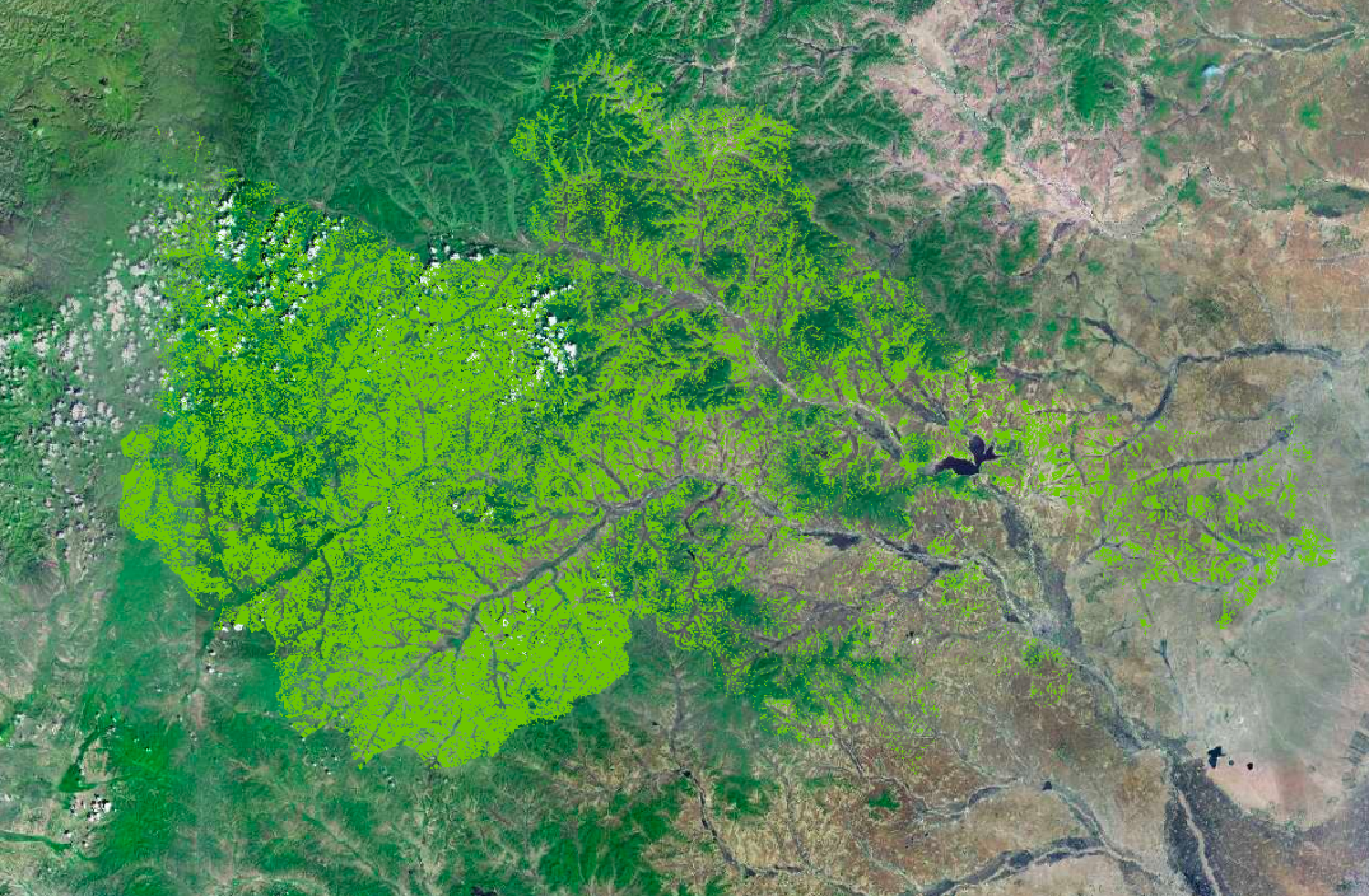
- Data Layers (dataFile)are divided into Raster Layer and Vector Layer.
- Raster Layer:
- Layers are displayed in PNG files with colors pre-rendered. Colors of the layer can not be changed in real time.
- To display the corresponding layers on the front end map application, load the following layer service URL (test link) as a map XYZ Tiles. https://dev-tile.terraqt.com/tile/xyz/{z}/{x}/{y}.png?path=7ffcdbe9-5042-40b4-bcbb-8c5905431b29/cor103/202005/CN-152221/rastertiles
- The layer loading effect is shown below (base map from Tianditu)
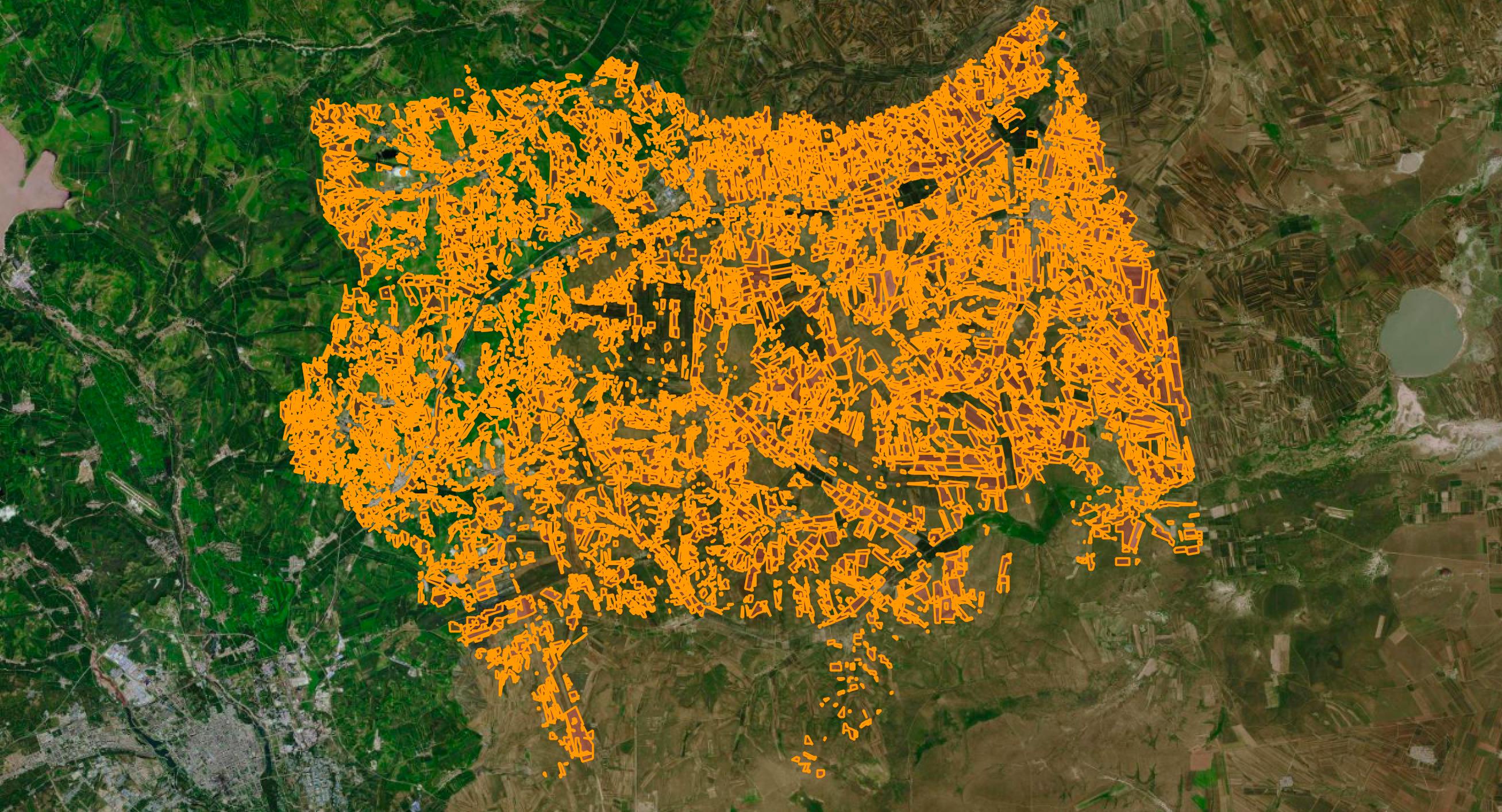
- Vector Layer:
- This layer displays vector polygons or vector points, and the colors need to be rendered in real time by the front end according to the configuration
- The vector layer may contain multiple vector polygons, and each vector will contain its corresponding attributes, which can be displayed in the map application as required
- To display the corresponding layers on the front end map application, load the following layer service URL (test link) as a map Vector Tiles. https://dev-tile.terraqt.com/tile/xyz/{z}/{x}/{y}.pbf?path=8a151451-fcb8-4eb1-b4a8-b814c1c448aa/cor1010201/202006/22c2b0a9-30d4-4f8b-8ea6-1206b79759da/vectortiles
- The layer loading effect is shown below (base map from Tianditu)
- Raster Layer:
- If you have questions, please check TerraQuanta’s layer rendering access example on GitHub — Github Page
- As of now, only layer rendering example with openlayer map framework is provided. If user is using different frameworks, one can contact TerraQuanta business personals for access examples of corresponding map framework
- If the map framework user uses does not support WMTS layer access, please contact TerraQuanta business personals for other types of layer data
- Rendering method of data layers contain single value rendering, interpolated rendering, and discrete rendering. Rendering example codes are provided in the examples
- Single value rendering (palette): In data layers, each value corresponds to some color
- Example:

- Example:
- Interpolated Rendering (interp): In the data layer, a certain value corresponds to a certain color, and the value between the two values is automatically selected as the intermediate color. For example, if the value is 0, the color is yellow, and if the value is 1, the color is red. If the value is 0.5, the difference between yellow and red will automatically generate orange to show the value 0.5.
- Example:
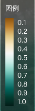
- Example:
- Discrete Rendering (discrete): In the data layer, one color is used to represent a numeric range of data. For example, green represents the data of crop growth from 0.800 to 1.000, and red represents the data of crop growth from 0.000 to 0.300
- Example:
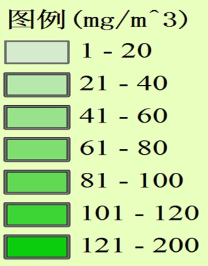
- Example:
- Single value rendering (palette): In data layers, each value corresponds to some color